CourseItineraries

- Itineraries
Model course
Itineraries
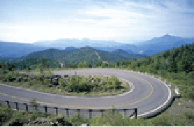
Bandai-Azuma Skyline
Bandai-Azuma Skyline
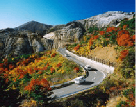
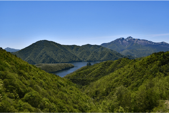
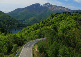
This route begins close to Takayu Onsen, weaves through the mountains, and emerges at Lake Inawashiro. It reaches up to 1622 m at its highest point, with an average elevation of 1350 m.As the seasons change, so too does the spectacular scenery along this route. Selected as one of Japan’s Best 100 Roads.
Seasonal sights: Yuki-no-Kairo (Snow Passageway) From the day it reopens until early May.
Spring Foliage: Early May until Mid-June
Fall Leaves
Jododaira Area: Late September.
Tengu-no-Niwa, Soryu-no-Tsuji, Umimi Pass: Early October.
Tsubakuro Valley, Tenpukyo: Mid-October.
Shirakaba-no-Mine, Kunimidai: Late October.
Point
About this Route
Fukushima-nishi I.C. (Tohoku Expressway)
Bandai-Azuma Skyline Takayu Gate
National Route 115, Prefectural Route 5 (Fruit Line), Prefectural Route 70. 15 km; 20 min.
Near Takayu Gate is Takayu Onsen Town, which has a distinctive sulfur smell from the natural hot springs.
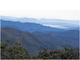
Shirakaba-no-Mine Peak
Look out onto a sea of birch trees that spreads across the Zao and Adatara mountain ranges.
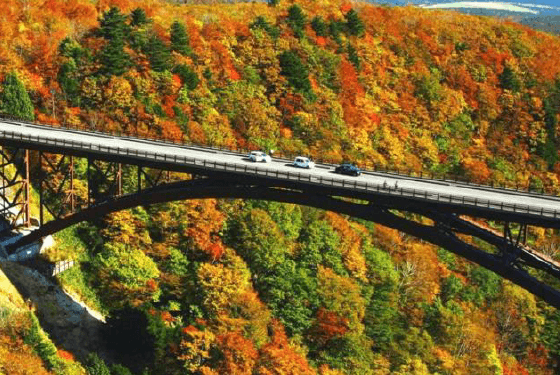
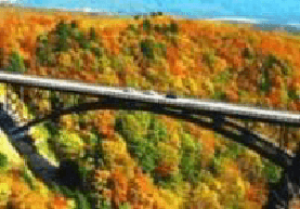
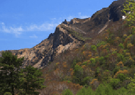
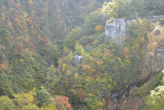
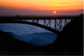
Tsubakuro Valley (Fudosawa Bridge)
At the time of its opening, this was the highest concrete bridge in Japan. The view of fall leaves from the bridge is a must-see. (Bridge Length: 170 m; Height: Approx. 84 m)
Tengu-no-Niwa
Legends tell of Tengu – spirits from Japanese mythology – dancing amongst the boulders that lie scattered about this picturesque garden. In fall, stunning foliage covers the slopes.
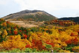
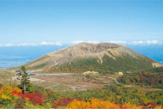
Jododaira
This wetland nestled between Mt. Issaikyo and Mt. Azuma-kofuji is a treasure trove of alpine plants. Enjoy walks around Mt. Azuma-kofuji, Mt. Issaikyo, Kamanuma Pond, and Okenuma Pond from this starting point.
Soryu-no-Tsuji
Soryu-no-Tsuji (‘Twin Dragon Road’) was named for its expansive view of the Adatara and Bandai mountain ranges, which resemble a pair of dragons confronting each other in the sky.
Umimi Pass
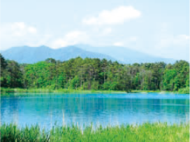
This ridgeline offers a panoramic view of Mt. Bandai encircled by Lake Inawashiro, Lake Akimoto, Lake Onogawa, and Lake Hibara.
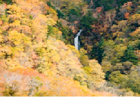
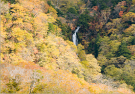
Tenpukyo
In fall, the vivid colors of Japanese beech trees together with the white ribbon of the exquisite Makunotaki Waterfall bring to mind a scene from a Japanese scroll painting.
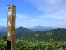
Kunimidai
A viewing platform with a panoramic view of the Aizu basin. Author Yasushi Inoue admired the view of the setting sun from this spot and described it as “gives the impression of the climax of a magnificent, symphonic poem”.
Tsuchiyu Gate
Hot springs such as Noji, Washikura, and Yokomuki Onsen are scattered throughout the area near Tsuchiyu Gate. Continue a little further down Route 115 to reach the town of Tsuchiyu Onsen.
Inawashiro Bandaikogen I.C. (Ban’etsu Expressway)
Model course
Itineraries
Lake Line
Lake Line
Depending on which side of Mt. Bandai you view it from, the mountain looks very different. Following this route, you can see both extraordinary faces of Mt. Bandai, while passing by lakes and waterfalls.Point
About this Route
Inawashiro Bandaikogen I.C. (Ban’etsu Expressway)
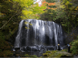
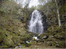
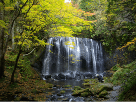
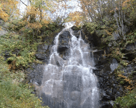
Tatsusawa Fudo Falls
The Fudo River originates at Mt. Funemyojin in the Adatara mountain range. Tatsusawa Fudo Falls are located along this river. The greater of the two falls gushes down over a sheer rock face, while on its west side, a smaller waterfall meanders down with quiet grace. They complement one another beautifully. At the base of the waterfall there is a shrine to Acala, a Buddhist god (known in Japanese as “Fudo”). While the atmosphere here is usually tranquil, it becomes lively with tourists coming to enjoy the scenery in fall and early spring.
Nakatsugawa Valley Rest House
Located beside the beautiful cliffs of the Nakatsugawa Valley, this rest house contains a shop, dining hall, and free rest area. The walking trail that descends into the valley has its trailhead next to this building. Those planning to hike nearby are able to use the rest house parking lot. For hungry hikers, we recommend the Aizu Jidori Soboro Don (rice topped with Aizu chicken mince), which comes as a set with ice cream made from locally produced eggs.
Sanko Paradise
A view spot from which you can look out at the three lakes of Urabandai, while Mt. Bandai stands in the background.
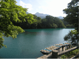
Goshiki-Numa Ponds
The emerald green Bishamon-Numa is the largest of the five lakes at Goshiki-numa Ponds. You can go boating here. There is also a walking course through the various lakes, in all their diverse colors, which takes about an hour one way. When you reach the end, you will find a local products center, where you can buy food and souvenirs.
Mt. Bandai Eruption Memorial Hall
In 1888, Mt. Bandai erupted in a steam-blast explosion. Lake Hibara, Lake Akimoto, and Goshiki-numa Ponds were formed as a result of this eruption. The items on display at the memorial hall provide an opportunity to learn about Mt. Bandai.
Kogane Daira
Get a close look at the crater wall that collapsed during the 1888 eruption of Mt Bandai.
Maboroshi-no-Taki
Little known before the establishment of the walking trail, this waterfall is known as Maboroshi-no-Taki (‘Phantom Falls’). A 5-minute walk from the Gold Line parking lot, cool off in the spray from the falls while taking in their mysterious beauty.
Bandaisan-Enichiji Historical Museum
Established in August 1987, this museum serves to preserve, protect, and promote the historic site of Enichiji Temple and its related cultural assets.
Bandai Kawahigashi I.C. (Ban’etsu Expressway)
Model course
Itineraries
Gold Line
Gold Line
Dive fully into nature with this route that passes around the waterfalls and canyons of the Bandai-Azuma area.Point
About this Route
Fukushima-nishi I.C. (Tohoku Expressway)
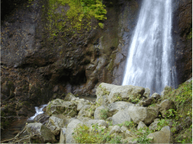
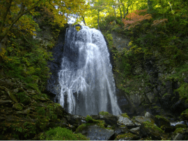
Takayu Fudo Falls
This waterfall descends from a height of 30 m. Beside the base of the falls there is a temple dedicated to the Buddhist god Acala. Areas of the path can be slippery, so please take care and wear appropriate hiking shoes.
Tsubakuro Valley and Fudosawa Bridge
This 170 m long, 84 m high bridge spans the Tsubakuro Valley. Enjoy a panoramic view of the Fukushima basin. There is a parking lot, rest area, and public toilet nearby. This spot is well-known for its fall leaves.
View of Makutaki Falls from Tenpukyo
In fall, the white ribbon of the exquisite Makutaki Falls runs through the vividly colored sea of beech trees
Tatsusawa Fudo Falls
The greater of the two falls gushes down over a sheer rock face, while on its west side, a smaller fall meanders down with quiet grace. They beautifully complementing each other.
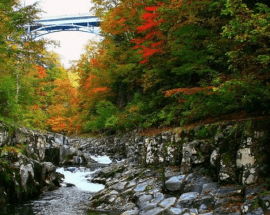
Nakatsugawa Valley
The cliffs, worn smooth by many years of raging torrents, make a stunning contrast with the clear river water. We recommend coming here to see the fresh green colors in spring, and the sublime reds in fall.
Onogawa Fudo Falls
This bountiful waterfall descends from a height of 25 m. The Ono river spring which sources it was selected as one of the best 100 natural water sources in Japan. It feeds into Lake Onogawa.
Maboroshi-no-Taki (Phantom Falls)
Best viewed in early Spring, when the water-level is high from melted snow.
Bandai Kawahigashi I.C. (Ban’etsu Expressway)
Model course
Itineraries
The
“Blessings of Volcanoes”
Course
The Blessings of Volcanoes
3 nights, 4 days (includes night of arrival)Visit two volcanoes ‒ Mt. Bandai, which last erupted in 1888; and Mt. Azuma, which is still active and discover the positive aspects of volcanoes.
Enjoy a range of activities, such as light trekking, canoeing, hot springs and bonsai.
Revel in the fiery foliage of fall, the most beautiful season of all.
Quoted from Ministry of the Environment Government of Japan
http://www.env.go.jp/nature/mankitsu-project/contents/
Point
About this Route
Night of arrival
Inawashiro Station
It is possible to stop by Lake Inawashiro en route.
You can enjoy views of the slopes of Mt.Bandai.
Inawashiro Town
Accommodation
Relax in hot spring baths at the accommodation.
Day1
Inawashiro Town
Morning
Urabandai
Prefectural Route 2, National Route 459, Approx 30 min by car.
Urabandai Visitor Center (30 min)
Explanation of natural features of the Urabandai area.
Taking advantage of being in an area of heavy snowfall, the center employs a natural cooling system that relies on accumulated winter snow.
The accumulation of snow can be observed.
Goshikinuma Pond Trail: Guided Tour (150min)
Admire beautiful landscapes of vividly colored volcanic lakes and mountains in Urabandai.
Urabandai Bussankan (product promotion center)
Noon
Kitashiobara Village, Urabandai District
National Route 459, Approx 5~30 min by car from Urabandai Visitor Center.
Aizu Salt Ramen or Mt. Bandai Geo-Curry (Lunch) (60min)
Mountain salt is refined by boiling down hot spring water, and has been produced since the Heian period. 7th-11th century
Afternoon
Lake Sohara or Lake Hibara
Prefectural Route 2, 20 min by car from Kitashiobara Village, Urabandai District.
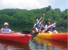
Kayak Experience at Lake Sohara
Kayak is the best way to truly experience Lake Sohara, the only sunken forest in the area.
Experience perfect tranquility as you glide across the lake, which is absent of any power boats and water gates, leaving you alone amongst unspoiled nature.
In the peace and tranquility, you can enjoy a jungle cruise-like experience in the sunken forest zone of the lake.
The stillness of the lake and dynamism of the surrounding scenery is sure to captivate you.
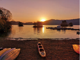
Canoeing Activity at Lake Hibara
On this canoeing tour you can voyage around the maze-like inlet of Ikarigata.
This area was formed when Mt. Bandai erupted 130 years ago and is made up of more than 40 small islands.
The open lake offers a panoramic view of the majestic Mt. Bandai, while the complex inlet consisting of numerous small islands, which is known as Ikarigata, makes you feel like you are on a thrilling jungle cruise.
It is sure to be an exciting experience right until the end!
Kitashiobara Village, Urabandai District
Prefectural Route 2, Prefectural Route 64, Approx 20 min by car from Lake Sohara or Lake Hibara.
Kitashiobara Village (Accommodation)
Day2
Kitashiobara Village
En route, you will pass the Bandai-Azuma Lakeline, and the Bandai-Azuma Skyline, one of Japan’s prominent mountain roads.This route boasts fantastic views.
Morning
Jododaira
National Route 459, National Route 115, Prefectural Route 30,Approx 20 min by car from Kitashiobara Village.
Jododaira Visitor Center (30min)
Discover the natural aspects of the Jododaira District.
Jododaira Astronomical Observatory (20min)
This is Japan’s highest altitude observatory, where you can observe starry skies in crisp, clean air. If the conditions are right, the sun can be observed even during the day.
The observatory is open in the evening until 10:00 p.m.
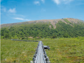
Trekking around Jododaira (30-240 min)
Choose one of several courses based on your fitness level, and enjoy a variety of marshlands, volcanoes, and volcanic lakes.
Noon
Jododaira Rest House (Lunch) (60 min)
Afternoon
Takayu Hot Spring
Prefectural Route 70, Approx 30 min by car from Jododaira.
Admire the views along the Bandai-Azuma Skyline, one of Japan’s prominent mountain roads.
Visit Takayu Hot Spring’s Source
Learn about the history of hot springs, the mechanics of transporting hot-spring water, the methods of cleaning hot springs,and the testing of hot spring efficacy, which will be demonstratedin front of you.
After the tour, relax in the nearby the public bath that draws its water from the source.
Fukushima City
Approx 5-40 min by car from Takayu Hot Spring.
Hot Springs in Fukushima City (Accommodation)
Choose from a variety of hot springs according to your needs,including Takayu Onsen Hot Spring, Tsuchiyu Onsen Hot Spring, and Nuruyu Onsen Hot Spring.
Day3
Fukushima City
Morning
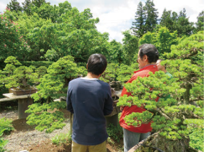
Bonsai Abe
Approx 10-30 min by car from Fukushima City Hot Spring.
Bonsai Experience at Bonsai Abe (120 min)
Behold bonsai cultivated from an Azuma goyomatsu pine one of Japan’s three major pine varieties from Mt. Azuma.
Enjoy a bonsai-making demonstration, a visit to a bonsai garden,and refreshments at a Japanese-style residence.
Noon
Fukushima Station
Approx 20 min by car from Bonsai Abe.
Around Fukushima Station (60 min)